First and foremost, heat is an expected thing in July! July is the hottest month for the Mid Atlantic region! There is always a tendency to promote a cause when we get an extreme. An event, over a short period of time, is NOT a trend or real “Climate” – Climate is determined by weather over a long period of time. Extremes are short-lived and do not impact the averages of weather over time. People that do not understand this will take one event and make a climate change argument. This hurts arguments no matter what you believe about Global Warming/Climate change. I am not here to debate that, so let’s get back to what causes heat in the weather.
Influences include:
- Soil Moisture
- Humidity and the Bermuda High
- Mountains
- Prevailing Winds
- Weather Patterns
Sinking Air heats up!
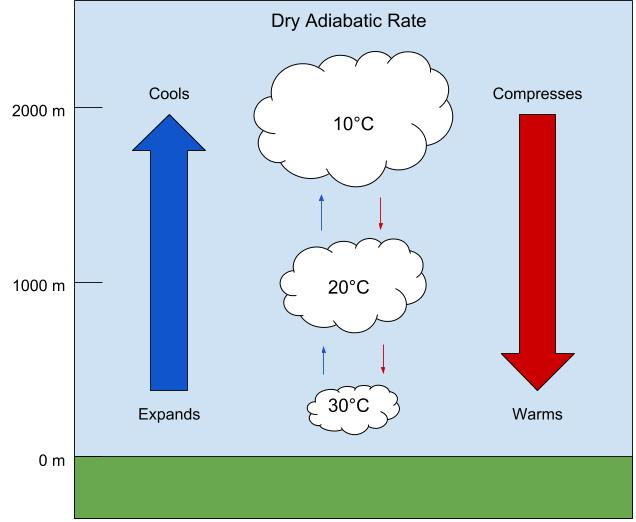
It is important to start with some science. Sinking air heats up. When air is compressed, it is warmer than when it is just there. Conversely, when air pressure is decreased, it cools. High-pressure systems have sinking air; thus, they can cause the warming air! Now, it is not just the higher pressure, it is also how big of an air mass the High Pressure is! When we get summertime high-pressure systems, they are full of hot air, and it sinks and causes very hot surfaces. These “heat domes” become increasingly hot about a month after the solstice (the lag effect), which is why July is the hottest month of the year! The current heat is coming from a very big heat dome that has just moved from Tennessee to North Carolina. It is expansive enough to be causing hot conditions and heat advisories all along the East Coast.
Heat Dome
How Mountains impact the heat
When we get winds that come down off the mountains, the air will also compress and cause it to be hot! This is especially prevalent in areas out in the western United States both in the desert Southwest, and into the west coast when they get Santa Ana winds!
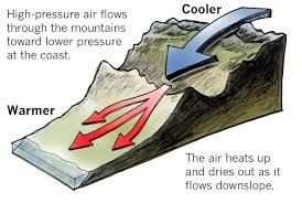
We have had that added factor quite a bit this year. Winds have been from the west, which has not only caused hot conditions, but also dried up the air a little bit. We have had a bit of a rain shadow here in the immediate Piedmont because of this phenomenon.
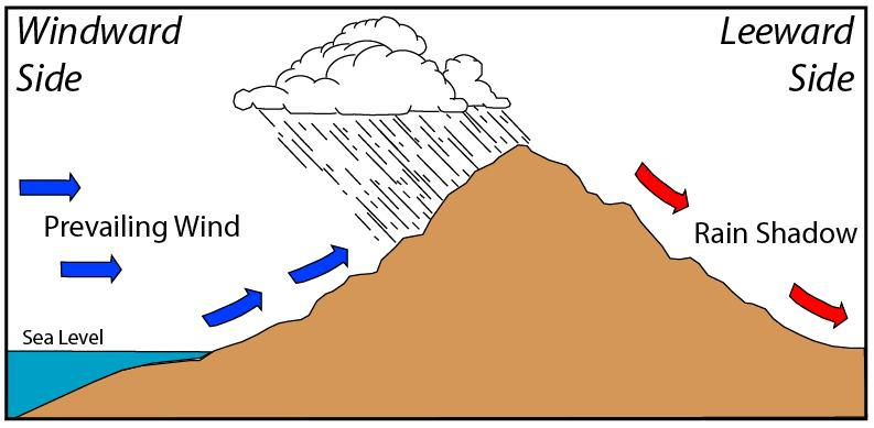
Drier air can also heat up faster (and cool faster too) – Now, if you go up the mountains, the air is a bit less dense and you get the inverse of the compression, to an extent, and thus, the mountains are a bit cooler. The colder temperatures as you go up in elevation is known as the Adiabatic Lapse Rate. That cooling rate is not a constant, and during the summer, tends to be less than other times of the year. But, in general, if you can get into the mountains, you will have about 10 degrees less temperatures.
Humidity and the Bermuda High
Humidity can do two things with the temperatures! The water in the air can actually keep the daytime highs lower as it absorbs some of the heat. BUT, without the evaporative cooling effect we get (like when you get out of a hot shower, and the moisture evaporates off your skin) we heat up! This is what aids in the Heat Index values as our bodies cannot get rid of the heat. Conversely, if we have drier air, a hot day can feel cooler than if it were humid. We tend to get hot and dry days in September days. August is the most humid month as we tend to get strong High-Pressure systems off the Southeastern coast near Bermuda. Called the “Bermuda High” it can set up any time of year. On the southerly winds it brings to our region, we get the humidity to soar. So, even though August can be “cooler” it feels as hot as July! We get the Bermuda high at any time, and the current heat system is poised to get to that region and pump up the humidity! This graphic is from Justin Berk
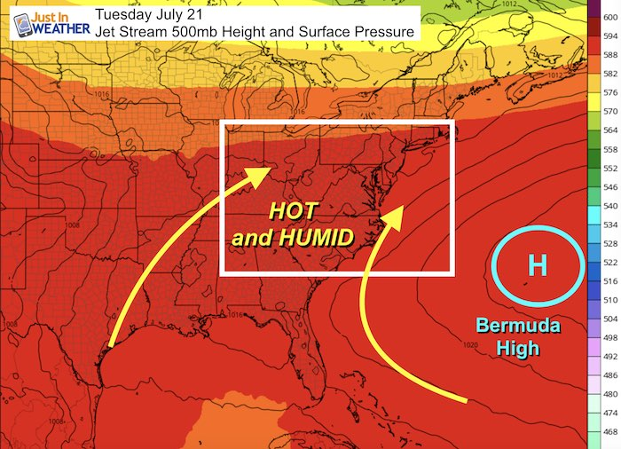
Southerly winds, bring the hot and humid tropical moisture into the picture! It is a terrible set up. This is such a common set up for the Mid Atlantic. It causes haze and makes the mountains looks like they have smoke in front of them.
Water in the air slows the heating of the atmosphere, but it also slows the cooling at night. Hot and humid days, turn to very warm and humid nights. This makes the nighttime lows way less than they could be if it were drier, and it does not take long the next day to get back up to uncomfortable levels.
Soil Moisture
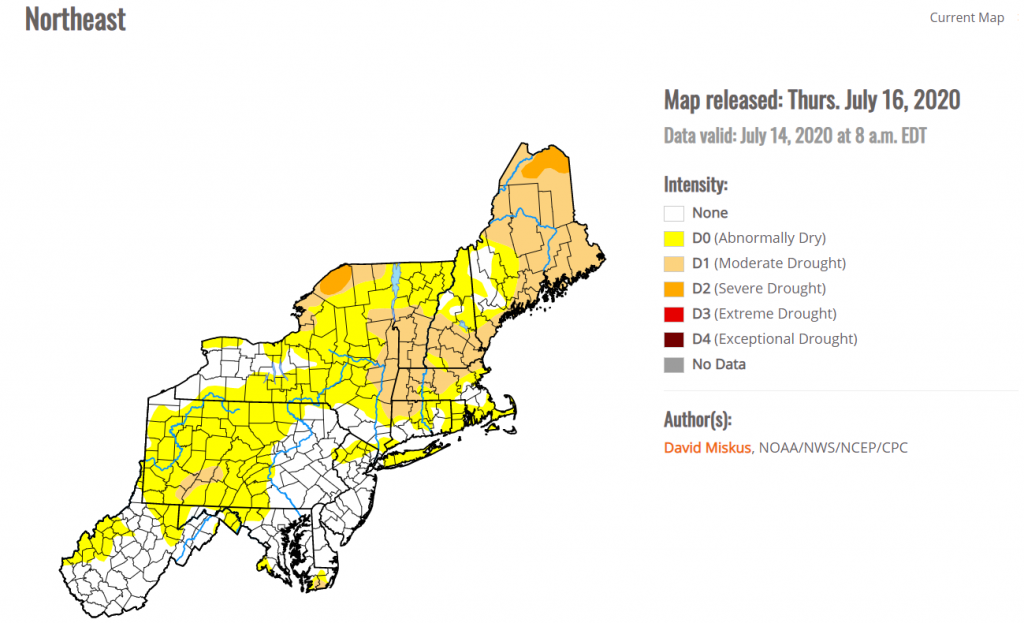
Water absorbs heat! If it is more humid, as mentioned above, temperatures tend to heat up slowly as the heat is absorbed in the water of the air. When the soil is wet, it also absorbs more heat. When we have droughts, the areas with less soil moisture, tend to experience higher temperatures. You see this in deserts as an extreme, but we have had serious issues like this in the United States in the past. During the Dust Bowl of the 1930s, the lack of soil moisture contributed to many of the record heat that we still have on the books today as the hottest temperatures in the United States. I am not certain if we are seeing this play out much here in the region, but I did think the areas that were drier did see a degree or two higher yesterday. In general, you would need a larger area to have below normal soil moisture to get the hotter temperatures. This has been a bigger factor in the past as we have just pockets of drier areas in the Eastern US, although Pennsylvania., and the Northeast is seeing some very dry conditions. We will watch to see if this expands!
Prevailing Winds
If you read back over the above, you will see many references to the wind direction and the impacts on the temperatures. Here is a rundown:
- Westerly – tends to warm the areas east of the mountains
- Southerly – Warmer temperatures and very humid
- Northerly – Usually cooler air. But, I have seen hotter air to the north in certain weather set ups in which warmer air came from the north. That is pretty rare
- Easterly – Depends on the ocean temperatures! Summer, this could mean cooler and humid. In the winter, warmer and still humid.
Conclusion
I hope the above helps you understand the influences on our weather when it comes to temperatures and what makes it hotter (or cooler).
Sources of Graphics
Drought Monitor – https://droughtmonitor.unl.edu/CurrentMap/StateDroughtMonitor.aspx?Northeast
Just Berk’s, Justin Weather https://www.justinweather.com/2020/07/16/july-16-weather-more-humid-and-breezy-before-bermuda-high-heat-wave-builds/
LA Times for the Santa Ana Winds – https://www.latimes.com/california/story/2019-10-09/what-makes-the-santa-ana-winds-blow
Wikipedia for Rain Shadow – https://en.wikipedia.org/wiki/Rain_shadow
And the Adiabatic Lapse Rate – http://pressbooks-dev.oer.hawaii.edu/atmo/chapter/chapter-5-atmospheric-stability/
