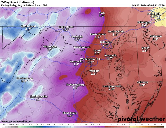
IT IS HOT! A Heat Advisory kicks in at noon and ends at 8pm. The rain focus has been hard to pinpoint the last few days. I am NOT HAPPY with the trends being east of us but, we can get some prolific rainers where storms can form.
We have a marginal risk (1 out of 5) for a severe storm, and wind would be the main threat. There are some hints that it could be raised today and tomorrow. I will be watching.
There are signs that we will get back to normal temperatures later next week and a continued chance of above-average rain.
THERE IS A CHANCE that we could get some influence from the tropical system that will be impacting the southeast. I do not have much confidence for us, but anyone heading to the beaches in the Southeastern US from Virginia to Florida should be thinking of some non-beach things to do because this system is going to be a problem! From rain to rough seas, this system could be a problem. SO MUCH UNKNOWN for now, but I will be updating as we look at the system through the weekend.
The forecast:
Today: Hi 97 ⛈️60% Lo 72 ⛈️60% 🌡️ – 🥵 Scattered showers and thunderstorms likely, becoming more frequent after 3pm. Mostly sunny and hot, with heat index values up to 104.
Saturday: Hi 90 ⛈️70% Lo 70 ⛈️60% – Isolated showers in the morning, then showers and thunderstorms likely from late morning.
Sunday: Hi 88 ⛈️50% Lo 69 🌙30% – A chance of showers and thunderstorms, especially after 11am.
Monday: Hi 94 ☀️ Lo 69 🌙 – 🥵 Sunny and mostly clear.
Tuesday: Hi 91 🌤️ Lo 68 ⛈️30% – Mostly sunny during the day. A chance of showers and thunderstorms at night.
Wednesday: Hi 87 🌤️30% Lo 66 ⛈️30% – Mostly sunny with a chance of showers and thunderstorms throughout the day and night.
Thursday: Hi 86 🌤️30% Lo 66🌙 – Mostly sunny with a chance of showers.
The total rain forecast for the next seven days is attached. You can note the downward trend from yesterday, but 1 to 2 inches is not bad! We can hope!

